
Land east of Station Lane, Kingswood
Site Context
Before drawing up proposals for the land east of Station Lane, we undertook our own assessment of the site to identify any potential constraints or opportunities, highlighted in the following plan:
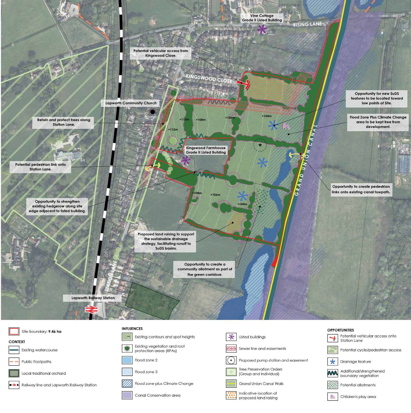
Plan showing potential constraints and opportunities affecting the site
This exercise flagged up the following issues in particular:
- Flood risk: Although the majority of the site in Flood Zone 1 (low risk), there are some areas of fluvial / surface water flood risk in the eastern part of the site (including the required allowance for the effects of climate change). These areas must be kept clear from development and can instead be used to provide a significant amount of publicly accessible open space.
- Trees along Station Lane: There are a significant number of high-quality trees on the site’s western boundary along Station Lane. We want to retain these trees; however, one or more of the trees would by necessity be lost if we were to provide vehicle access to the site directly from Station Lane.
- Hedgerows within the site: The site comprises a number of small fields separated by hedgerows. While breaks will need to be created to facilitate access across the site, we want to retain as much of these hedgerows as possible.
- Neighbouring properties: There are several properties directly adjacent to the site, mainly on Kingswood Close but also a few on Station Lane, and the amenity and privacy of these properties must be maintained. As it happens a sewer runs through the site behind properties on Kingswood Close, so development will have to be set further back from these properties in any event.
- Potential for vehicle access from Kingswood Close: The site is directly adjacent to the eastern end of Kingswood Close, which presents an opportunity for vehicle access to be provided here instead of on Station Lane, preventing the removal of one or more trees along Station Lane.
- Potential for pedestrian / cycle link from Station Lane: A narrow strip of land in the south-western corner of the site could provide pedestrian, cycle and emergency vehicle access direct from Station Lane, creating a logical and convenient route for active travel (i.e. walking and cycling) between the site and the village centre.
- Lack of a footway along much of Station Lane: There is currently no footway along a large stretch of Station Lane, with the footway up the western side of Station Lane from the station coming to a stop just before No. 145. There is a need to improve pedestrian connectivity between the site and the village centre so that walking can be a safe and realistic option.
The draft Local Plan identified the site to deliver up to 251 homes before the site was removed from the Plan. However, in light of the site characteristics outlined above, we think it would be more appropriate for the site to deliver up to 125 homes only. This approach will help to ensure that the development of the site can be landscape-led and respond better to the site’s existing context, maintaining as many trees and hedgerows as possible, providing lots of publicly accessible open space, and providing sufficient space for a robust sustainable drainage system to manage surface water flood risk.
Contact Us
If you have any queries, please contact Charlotte Matthews of SP Broadway on 07503 201 876 or at charlotte@spbroadway.com